
Wintergreen in 3D: the mountain and the valley.
Wintergreen Resort sits on the mountain, and Stoney Creek lies in the valley below. This model shows the ground between them, from Devils Knob down to Route 151: the ski slopes, both golf courses, Lake Monocan and the road up.
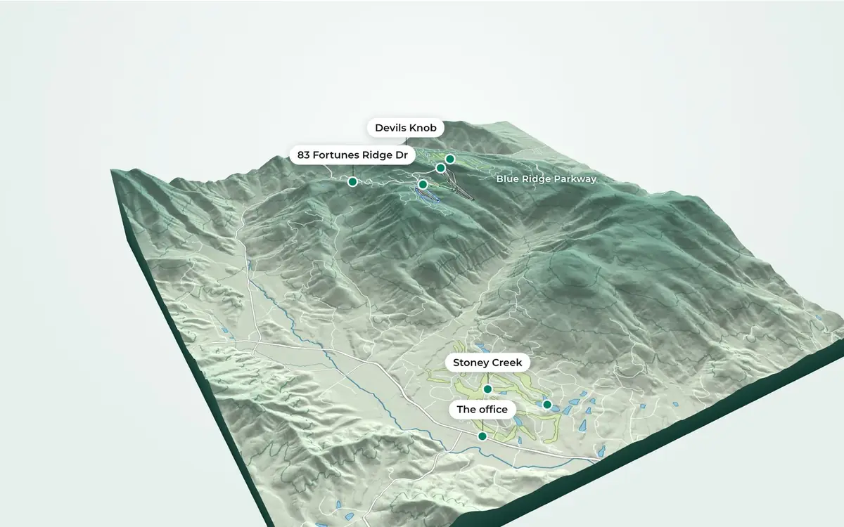
Drag to turn. Scroll or pinch to zoom. Two fingers or Shift-drag to move.
Mile 0.0
The 3D model could not start on this device. The picture above and the list below show the same places.
The places in the model.
Each elevation is read from the USGS elevation grid at that place, to the nearest 10 feet.
-
The firm's featured listing
83 Fortunes Ridge Dr
About 2,800 ft
A 1980 log home in Wintergreen Resort: stone fireplaces, wide pine floors, exposed beams and a hot tub on the deck. The pin is the address's approximate location.
-
Mountain Inn Loop
The resort village
3,240 ft
Wintergreen Resort's ticketing and ski rental, on Mountain Inn Loop, where the drive up Wintergreen Drive ends.
-
The summit
Devils Knob
3,850 ft
The summit above the resort, higher than its homes, its slopes and its golf course.
-
The valley
Stoney Creek
630 to 880 ft
A 3,000-acre community in the valley below the mountain resort, in the firm's words, with 27 holes of golf, Lake Monocan and trails. The elevations are those of its golf course.
-
Nellysford
Wintergreen Real Estate
670 ft
The firm's office, on Route 151 in Nellysford. 3079 Rockfish Valley Hwy, Nellysford. Daily, 9:00 am – 5:00 pm.
-
Stoney Creek
Lake Monocan
680 ft
The lake in Stoney Creek, which the firm's Stoney Creek page names.
-
Highlands Express chairlift
Top of the ski lifts
3,500 ft
The upper end of the Highlands Express, the highest lift station in the model. The firm's weather page gives the resort's top elevation as 3,515 feet.
-
Golf on the mountain
Devils Knob Golf Course
3,240 to 3,820 ft
The mountain course. The firm's Wintergreen Resort page counts 45 holes on two courses, Devils Knob and Stoney Creek.
From the valley floor to the summit.
- Devils Knob above the office in Nellysford
- 3,180 ft3,850 ft at the summit, 670 ft at the office.
- The resort village above Stoney Creek's golf course
- 2,510 ftAgainst the course's median elevation.
- The drive up, Route 151 to the resort village
- 7.3 milesClimbing 2,410 ft, an average grade of 6.2%.
The drive up
Route 151 to the resort village: 7.3 miles, 2,410 ft up.
From Route 151, the road up follows Beech Grove Road, then Wintergreen Drive, then Mountain Inn Loop. It starts at 830 ft and ends at 3,240 ft by the resort's ticketing and ski rental, an average grade of 6.2%. Distances are measured along OpenStreetMap's roads.
To 83 Fortunes Ridge Dr, the same road is 6.2 miles from Route 151: Beech Grove Road, then Wintergreen Drive, then right onto Fortunes Ridge. It climbs 2,010 ft to 2,840 ft where the street reaches the house, whose location is approximate.
Mountain or valley, side by side.
From the firm's guide, Wintergreen or Stoney Creek (updated July 2026).
| Wintergreen Resort condos | Stoney Creek homes | |
|---|---|---|
| Setting | On the mountain, near the slopes | In the valley below the resort |
| Typical use | Second homes, rentals, lock-and-leave ownership | Year-round and full-time living, second homes |
| Signature amenities | Ski access, mountain views, resort pool and spa, village and restaurants | Golf (27 holes), Lake Monocan, trails, larger lots |
| Access in winter | Mountain roads; snow is part of the appeal | Valley elevation; generally easier access |
| Maintenance | Lower: the condo association handles the exterior | Higher: single-family responsibility |
| Rental demand | Strong year-round, especially ski season | Steady, golf and summer driven |
How this model was made.
- Terrain: the USGS 3D Elevation Program's bare-earth elevation service (data as of 26 October 2026), read on 3 November 2026 for the ground between longitude 78.985° and 78.855° W and latitude 37.86° and 37.96° N, at about 11 by 14 m. The model averages it to about 44 by 55 m. USGS elevation data is in the public domain.
- Map features: ski runs, lifts, golf courses, roads, rivers and lakes from OpenStreetMap, as of 2026-11-03. © OpenStreetMap contributors, available under the Open Database License. Ski runs are coloured as the trail signs are: green, blue and black, with the terrain park in orange.
- Heights are drawn at 1.5 times true scale so the slopes read on a screen. Contour lines are every 100 feet, with a heavier line every 500 feet.
- Elevations are read from the grid at each place, to the nearest 10 feet. At the top of the lifts the grid reads 3,500 ft; the firm's weather page gives the resort's top elevation as 3,515 feet.
- 83 Fortunes Ridge Dr is placed at its address's approximate location. Its details are as the firm's listing showed them on 2 November 2026; see the listing for its current status.